 Search: wisconsin
Search: recreation
Filter: Categories of Wisconsin Historical Images
Search: wisconsin
Search: recreation
Filter: Categories of Wisconsin Historical Images

| Date: | 1970 |
|---|---|
| Description: | This colored map displays a brief description of tourist attractions in the state, as well as a grid of state parks and recreational facilities. There is a... |

| Date: | 1972 |
|---|---|
| Description: | This colored map displays Wisconsin and bordering areas of Iowa, Minnesota, and Michigan. There is color-coding on the map to indicate National Forests, an... |

| Date: | 1973 |
|---|---|
| Description: | This map displays, in color, Wisconsin and bordering areas of Iowa, Minnesota, Illinois, and Michigan. At the bottom is a map key indicating road classifi... |

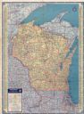
| Date: | 1977 |
|---|---|
| Description: | This colored map displays Wisconsin and portions of bordering states, including a detailed map of the Wisconsin Dells area. Surrounding the map are multipl... |

| Date: | 1966 |
|---|---|
| Description: | This colored road map shows automobile roads in Wisconsin as well as portions of nearby states. Information on the quality and type of any road shown (inte... |

| Date: | 1973 |
|---|---|
| Description: | This colored map displays Wisconsin and bordering areas of Iowa, Minnesota, and Michigan. There is color-coding on the map to indicate National Forests, a... |

| Date: | 1976 |
|---|---|
| Description: | This color map displays Wisconsin and bordering areas of Iowa, Minnesota, Illinois, and Michigan. At the bottom is a map key indicating road classification... |

| Date: | 1976 |
|---|---|
| Description: | This colored map displays Wisconsin and portions of bordering states, including a detailed map of the Wisconsin Dells area. Surrounding the map are multipl... |

| Date: | 1971 |
|---|---|
| Description: | This colored map displays Wisconsin and bordering areas of Iowa, Minnesota, and Michigan. There is color-coding on the map to indicate National Forests, an... |

| Date: | 1966 |
|---|---|
| Description: | This colored road map shows automobile roads in Wisconsin as well as portions of nearby states. A map key indicates relative sizes of cities and towns. On ... |

| Date: | 1933 |
|---|---|
| Description: | This map contains automobile routes across Wisconsin and portions of Illinois, Iowa, Minnesota and Michigan as well. The state borders are clearly defined... |

| Date: | 1936 |
|---|---|
| Description: | This colored road map shows automobile roads in Wisconsin as well as portions of Michigan, Iowa, Minnesota, and Illinois. U.S. numbered highways are shown ... |
| Date: | 1937 |
|---|---|
| Description: | This colored road map shows automobile roads in Wisconsin as well as portions of nearby states. Information on the quality and type of any road shown (pave... |
| Date: | 08 26 1960 |
|---|---|
| Description: | Miniature model of the Wisconsin Dells. Goggled diver, Ollie Reese, swimming with Dells recreation boat. This completely landscaped exhibit was built to sc... |
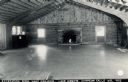
| Date: | 1950 |
|---|---|
| Description: | Photographic postcard view of the recreation room at Kamp Kenwood on Lake Wissota. Caption reads: "Recreation Room Kamp Kenwood on Lake Wissota, Chippewa F... |

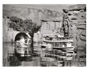
| Date: | |
|---|---|
| Description: | Colorized postcard view from pier towards a large recreation building. The excursion boat "Miss Geneva" is under an awning on the right. Caption reads: "Mu... |
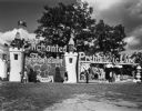
| Date: | |
|---|---|
| Description: | Entrance to Enchanted Forest and Prehistoric Land. |

| Date: | 12 02 1948 |
|---|---|
| Description: | Five University of Wisconsin students in the Community Leadership in Recreation curriculum are watching Prof. James Schwalbach demonstrate metal work in th... |

| Date: | 1928 |
|---|---|
| Description: | Illustrated map of points of interest, including University buildings, parks, athletic venues, fraternity and sorority houses, and state buildings. |

| Date: | 08 13 1952 |
|---|---|
| Description: | Portrait of Fritz Wegner, University of Wisconsin assistant basketball coach and Director of boys' baseball, Madison Schools, Division of Recreation. |
If you didn't find the material you searched for, our Library Reference Staff can help.
Call our reference desk at 608-264-6535 or email us at: